Showing posts with label vintage campers. Show all posts

Thursday, January 16, 2014

San Joaquin Historical Society and Museum in Micke Grove Park, Lodi, CA

History comes alive in Micke Grove Park!  Nestled in the 258 acre county park just south of Lodi, California is the San Joaquin Historical Society and Museum. With eight large exhibit buildings packed with Native American, pioneer, Gold Rush and agricultural history, and four historic buildings including the Charles Weber Cottage dating to 1847 and the Calaveras School, 1866, it's one of the state's best historical museums.
A class of third graders, taking part in the summertime ‘Valley Days’, receive a day’s education just as it was offered in the 1880s (here they enjoy lunch on the grass)
This 1859 prairie schooner stands more than 8 1/2 feet tall, is made of New England hardwood and was loaded with 1600 pounds of household goods and food for the five-month trip across the United States to California
 
Blue farm wagon, built by Truscott and Sons of Stockton in 1910, it cost $250 and was used by the Brassesco family to haul fruits and veggies to markets in Stockton and Lodi
The museum has literally scores of vintage tractors, crawlers and Caterpillar tractors
Pacific Fruit Express refrigerated rail car: this car was built in 1957, an ice-cooled steel car which could haul 80,000 pounds of produce to markets in the East. Mechanically-cooled cars would not come into production until the 1960s
 
Huge dredge bucket towers over two kids: this huge dredge bucket was used on the San Joaquin Delta to dredge waterways and build the levies that held back the San Joaquin River And Delta

Here a docent works with a young visitor in helping her make a corn husk doll during the Festival of Trees

Within the large park you'll also find the stunning Japanese Gardens, the Fun Town Amusement Park and the Micke Grove Zoo, surrounded by lots of picnic areas placed amongst stately Valley Oaks. The park offers so many options in addition to the museum, you'll spend a long day, or return, time-and-again.

Inside the museum's ongoing exhibits are many examples of early pioneer and Gold Rush transportation. Included in the collection is an original prairie schooner, one of only several left in existence, dating to 1859, many farm wagons, buggies and all manner of early farm equipment. The museum is rich in old farm implements: plows, harvesters, tractors, Holt and Best crawlers, Caterpillar tractors, John Deere tractors and many more.

Wander through the museum's exhibit buildings and get a sense of life in the 1860s through the early 1900s, or picture life on the prairie crossing the US to California. Life on the farm is clearly depicted from more than one hundred years ago; the exhibits clearly paint a picture of life that was then a bit harsher than what we enjoy today!

A large contingent of historically-correct docents are available to give you tour tips and interpretive information. Of special interest for kids, coming on Fridays and Saturdays, March 7-24, is the Critter Corral, offering a petting corral with a variety of farm animals! On any given day, docents will help bring history to life for kids from 5 to 95!

Directions: the museum is located inside Micke Grove Park, at 11793 N. Micke Grove Rd., Lodi. From Interstate 5, go east on Eight Mile Road, then left on Micke Grove Road. Admission: Just $5 for adults, seniors (65+) and teens are $4 and kids (6-12), only $2. The park also has a vehicle admission fee. Winter museum hours are Wednesday through Sunday, 11 AM to 4 PM.

For more information, go to www.sanjoaquinhistory.org, or call (209) 953.3460. For additional Weekend Getaway ideas, go to http://LittlePlacesIKnow.blogspot.com. Take the family and make a fun day at Micke Grove Park and the museum!

Wednesday, January 15, 2014

Rancho Seco Nuclear Power Plant and Park in South Sacramento County

Towering 300’ into the sky in south Sacramento County are the Rancho Seco Nuclear Power Plant’s twin cooling towers and Rancho Seco Park, complete with swimming, fishing and camping in a pristine setting. Just 25 miles from both Stockton and Sacramento, the old nuclear plant is worth a visit and the park’s amenities will bring you back for recreation throughout the year!
The300' tall twin nuclear cooling towers are visible from miles away 

The containment building that housed the nuclear reactor on left, with the cooling towers at right

An aerial view of the nuclear plant, from SMUD web site

Rancho Seco Lake, and Park, with the cooling towers in the distance

Nuclear plant: Sacramento Municipal Utility District (SMUD) bought the property in the 1960s, and built the nuclear plant, which went on-line in April, 1975. In March, 1978, a power failure in the plant’s instrumentation led to a steam generator ‘dry-out’, a precursor, had other failures followed, to a nuclear near melt-down like the Three Mile Island nuclear plant on the east coast.

After operating at a reduced capacity until 1989, a public vote lead to the closing of the plant. It was decommissioned and the nuclear equipment was removed. Today, a gas-powered plant produces electricity on the same lines that the nuclear plant used; nearby SMUD has also developed solar-generation facilities. At about the same time, a Stanislaus County nuclear plant was proposed by PG&E, but was cancelled in 1979. Over 60 US nuclear plants were cancelled in the late 1970s, as public confidence in their safety reached a low point.

Rancho Seco Park: The 160 acre Rancho Seco Lake was developed as an emergency source of water for the plant; today it is a stunning public park, offering swimming, fishing, hiking, bird-watching and camping. A nice public beach offers warm-weather swimming, while fishing goes on year-round (sunfish, catfish, trout are found in the lake, and non-motorized boats are welcome).

The nearby Howard Ranch Trail and the Amanda Blake Memorial Wildlife Refuge are the latest additions to the park. The trail offers a seven mile hike in rolling valley foothills while the refuge offers superb viewing opportunities to see geese, hawks, ducks, blue heron, occasional bald eagles and migratory birds in the winter months.

Camping on the lake shore offers 25 tent sites and 18 RV sites with electric and water hookups. Plenty of picnic options, including group picnic sites, are available throughout the park. Near the park recreation room, WiFi access if also offered!

Getting there: Rancho Seco Park is located at 14440 Twin Cities Road, in Herald, CA 95638; from either Interstate 5 or Hwy 99, go east on Twin Cities Road.  

For more information: Call 800-416-6992 for park info; or see the web site, www.smud.org/en/about-smud/community/recreational-areas/rancho-seco-lake.htm. For additional weekend getaway destinations, see http://LittlePlacesIKnow.blogspot.com!

Tuesday, December 24, 2013

Tuolumne City, CA and Westside Lumber Company; Gold Rush and lumber capital

Tuolumne City preserves remnants of the old Gold Rush town of Summersville, as well as lots of pieces of its longer-lasting hay-day as a logging and lumber center of the Mother Lode. Just six miles from Highway 49 and regional center Sonora, it offers history, and fun at nearby Black Oak Casino, for all ages, from one to 100!
Huge old Steam Donkey awaits bygone lumbering operations next to Tuolumne Fire Station

Eves of the Westside Lumber main mill reflect its closure some 50 years ago

The old Westside Lumber Mill building is in a stage of accelerated disrepair, having closed in the early 60s

Tuolumne City's Memorial Auditorium is in use as a town gathering hall

Massive old lumber equipment dots the fields around the Toulumne City boundaries

Westside Lumber's Engine #2 is preserved in the city's park
Westside Lumber at height of its operations (photo courtesy of Tuolumne Museum)
Early history: Tuolumne began in 1854 when Franklin Summers and family settled nearby and built a cabin and began to grow crops. In 1856 James Blakely arrived and discovered the first quartz outcropping, which would become his “Eureka” quartz and gold mine. Soon the initial town of Summersville had taken shape, with shops, restaurants and service providers.

Other nearby mining towns would spring up (and then disappear), Lone Gulch, two miles south, and Cherokee, two miles north. Later named Cartersville, then Tuolumne City, the placer gold would quickly be mined out, and the area became both an agricultural center and the heart of logging and lumber production for cities in the valley like Modesto and Stockton.

Of several logging operations, the Westside Lumber Company became the main player, building a narrow gauge railroad into varied portions of the Sierra forest, buying and uniteg several other narrow-gauge Sierra railways and developing a major lumber mill with regional innovations. It would continue to expand its railroad, the size and complexity of its mill, and develop Tuolumne City into a lumber town of major proportions in the first sixty years of the 20th century. The mill closed in the early 1960s, after a major fire during a labor dispute - the town has struggled to maintain its viability since.

More recent history: Today, portions of the lumber empire of the Westside Lumber Company take center stage. Several of the company’s buildings remain, though in states of disrepair. Remnants of logging equipment dot the town, from a huge Steam Donkey next to the fire station, to pieces of lumbering equipment in varied fields on the edge of town, the lumber company’s Steam Engine #2 in the city park, to the city’s Municipal Auditorium and the local museum. There is much to explore in a short walk of a few to a dozen blocks. A mile to the north east is the huge, new Black Oak Casino, which is bringing new vitality and visitors to the area, and pumping investment into the town as well.

What to do while there: Walk the historic streets, see the old lumber company remnants, tour the city’s museum (open Saturdays and Sundays, 1-4 PM excluding holidays, at 18663 Carter Street, (209) 928-3516; http://tuolumnemuseum.wordpress.com/), and visit the Tuolumne-band of the Miwuk Indian’s Black Oak Casino (www.BlackOakCasino.com; just a mile from the city center).

How to get there: Tuolumne City is located just off historic Highway 49, six miles southeast of the regional city of Sonora by following Tuolumne Road. It is just two hours from Sacramento and one hour from Stockton and Modesto.

Nearby attractions: Nearby Gold Rush towns like Sonora, Twain Hart, Columbia and Jamestown make for a nifty collection of historic towns in the Mother Lode; many will make their trip several days to take in the rich history and scenic beauty of the Sierra foothills. And the Black Oak Casino is worth a visit, with fun for all.

Lodging, camping, dining options: While Toulumne City offers no hotels or motels, nearby Black Oak Casino offers hotel accommodations, several cafes and a fine restaurant, the Seven Sisters. Sonora, just six miles away, offers a wealth of motels, hotels, bed and breakfasts and a number of good to fine restaurants. Campgrounds can also be found along Highway 49, and up Highway 108 in the Sierras.

For additional weekend getaway ideas in California and the west, go to http//LittlePlacesIKnow.blogspot.com.

Sunday, December 15, 2013

Columbia, CA, gem of the Mother Lode and living history park!

Today, Columbia State Park preserves the old Gold Rush town of Columbia as a museum of living history! Open seven days a week, all year, the park offers activities and history for all ages, from one to 100!


The Wells Farge stage still serves up fun rides to Columbia visitors


Columbia's main street is lined with historic buildings and staffed by friendly guides and docents to recreate life in Gold Rush mining town of the 1850s

Columbia's Fire House was built to prevent future fires that all but destroyed
the town in 1854 and 1857, before most structures were rebuilt in brick with fire-safety in mind

Two young prospectors learn to pan for gold, or, at least, agates!

The Wilson-McConnell House dates to the 1870s, and was used in the film 'High Noon'


On sunny afternoons, lots of families with kids line up to try their hand panning for gold!
History: Columbia took root in March, 1850, when Dr. Thaddeous Hildreth, his brother and others settled here and began prospecting for precious gold. Soon, Hildreth Diggin’s was prospering and in weeks more than a 1,000 miners had turned out into the area. The gold camp was initially named American Camp, and, eventually, Columbia.

The immediate challenge was a steady water supply, used to both wash down gold out of hillsides and to sluice gold out of gravel deposits. Because no steady streams were nearby, by 1851 the locals had formed the Tuolumne County Water Company, to bring water to the town. Since its rates were deemed too high, in 1854 another company was formed, the Columbia and Stanislaus River Water Company, to bring water from 60 miles distant.

By the late 1850s, the two had merged, and use of the water began to change the landscape. It is estimated that the current park parking lot, and area where kids pan for gold was once 25-30 feet higher, before water was used to wash the gold out of the soil and gravel!  All told, approximately $87 million (at 1860's prices) came out of the mines around Columbia!

Within years of its founding, the prosperous town had streets well laid-out, and well over 100 shops, saloons, bakeries, blacksmith shops and restaurants were catering to thousands of miners and townsfolk. Columbia would add churches, the Sons of Temperance, a Masonic Lodge, hotels and a concert hall; the town's population would swell to almost 6,000 towns people. 

Originally, almost all the buildings were made of wood, and a huge fire swept the city in 1854, destroying most of the wooden buildings in the business district. Most of these were rebuilt in 1855, but a second fire in 1857 destroyed more framed buildings and some of the brick ones; the town again rebuilt and further emphasized state-of-the-art fire suppression and fire-fighting.

By the early 1860s, most of the easiest placer gold had been tapped out, and the town began a slow decline. In the following 20-some years, many of the vacated buildings were torn down, and their sites were mined for gold. By the late 19th century and into the 20th, the town was in visible and steady decay - residents had dropped to just 500.

Recent history: An idea born in the Roaring 20s took hold, to establish and renovate Columbia as a State Park, an idea that was finally made reality in 1945! Today, Columbia’s business district is closed to all but foot traffic, and a host of businesses, shops and volunteers bring the town to life, much as it appeared in 1855!

What to do while there: Take a stage coach ride, pan for gold, tour blacksmith and livery shops, get a free tour led by period-dressed docents, grab lunch or an ice cream, and take in life as it was more than 150 years ago! Best of all, admission, parking and guided tours are free, so a day spent here is easy on the wallet!

How to get there: Columbia is located just off historic Highway 49, and is just two hours from Sacramento and 1.5 hours from Stockton.

Nearby: Gold Rush towns like Angels Camp, Amador City, Sutter Creek, Sonora, Tuolumne City and Jamestown make for a nifty collection of historic towns in the Mother Lode; many will make their trip several days to take in the rich history and scenic beauty of the Sierra foothills.

To plan your visit, go to www.visitcolumbiacalifornia.com or call the State Park at (209)-588-9128. For additional weekend getaway ideas in California and the west, go to http//LittlePlacesIKnow.blogspot.com.

Saturday, December 14, 2013

Fiddletown and Plymouth, CA are interesting Gold Rush stops on historic Highway 49

Travelers on historic California Highway 49 will be familiar with Plymouth, CA, but less so with Fiddletown, just eight miles east off 49 following the Fiddletown Road.
The Fiddletown Community Center, with giant fiddle over the entrance, is a backdrop to thousands of photos; last time we were there, the center was hopping with a pancake breakfast for area residents!

The Chew Kee Chinese Apothecary is an example of a rammed-earth building dating to the 1850s

Old Chinese General Store and other Chinese-established businesses line a portion of the old Fiddletown Road that passes through the historic downtown area (easily walkable; only three blocks long)
The C. Schallhorn Blacksmith and Wagon Store has stood along Fiddletown Road for well over 150 years

Stately, and broken, Valley Oaks line a host of scenic backroads throughout the Fiddletown and Shenandoah Valley area, and offer homes for wild turkey, deer, racoons, skunks and more!

Both towns, approximately 45 miles east of Sacramento and 60 miles northeast of Stockton, are rich in Gold Rush history and offer explorers a wealth of interesting historic sites, shops, restaurants and wineries ripe for the touring! And, at 1,000 to 1,500 feet elevation, both are generally well below the Sierra foothills snowline, making sunny winter days the perfect time to tour!
Fiddletown traces its Gold Rush history back further than Plymouth (though Plymouth, located on Highway 49, is larger and better known). Fiddletown was established by prospectors from Missouri in 1849, and quickly grew in the 1850s and 1860s as a center of trade for many mines located nearby.

Miners were known, during the dry season when water for their hydraulic mining ran low, to just “fiddle around”, hence the town’s name. A wealthy resident, Columbus Purinton, embarrassed to say he was from the city of Fiddletown, petitioned the state legislature to rename the town Oleta (after a woman he knew) in 1878, but on his demise 50 years later, it reverted to the Fiddletown name.

During the city’s boom years, it numbered almost two dozen businesses, a handful of taverns, blacksmith shops, bakeries and restaurants. With a post office, church and school, it was a full-fledged city. The town soon grew to over 2,000 residents, with over half Chinese, who worked the mines and established many of the early businesses (some of these still stand, though in a state of disrepair, the local Fiddletown Preservation Society is working to refurbish several structures).

While touring the several remaining blocks of old Fiddletown, be sure to check out the Chew Kee Apothecary (a rare “rammed earth” building dating to the 1850s), the other old Chinese merchant buildings, C. Schallhorn’s Blacksmith and Wagon Store and the Fiddletown Community Center with the giant fiddle over the door! While exploring the historic main drag, don’t miss Brown’s English Toffee, a candy-store extraordinaire (they also sell cute “I’m on Fiddletown Time” t-shirts)!

Nearby Plymouth traces its history to the 1870s, when prospectors stopped there in search of quartz and gold. For gourmet travelers, the new Taste Restaurant in Plymouth is a must-stop, drawing rave reviews from around the region. The city has a cute public park with bandstand, the old Plymouth Hotel and other eateries, all grouped along several old-town blocks. Nice motels also call Plymouth home, and several bed and breakfasts cater to travelers and wine aficionados. For info on restaurants and lodging, go to: http://www.historichwy49.com/amador/plymouth.html.

Both Fiddletown and Plymouth are known as “Gateways to the Shenandoah Valley”, home to over 30 wineries and fast-becoming known as the scenic home to very skillful wine-makers.  While touring a variety of scenic backroads through the Shenandoah, watch for wild turkeys and deer, both found in abundance in this bucolic setting!

Take a weekend to explore both towns and enrich your Gold Rush history! For additional weekend getaway destinations, see http://LittlePlacesIKnow.blogspot.com.

Sunday, December 1, 2013

Big Sur, CA, between Monterey/Carmel and San Simeon/Hearst Castle

What is scenic, wild, historic, contains some of the state’s finest campgrounds, restaurants and resorts and is just 150 miles south of San Francisco? It’s Big Sur, that relatively undiscovered paradise of rocky coast, idyllic coves, deep redwood forests and legends that run deep, spread along Highway One!

Historic Bixby Bridge on Hwy 1 is a "show stopper"!

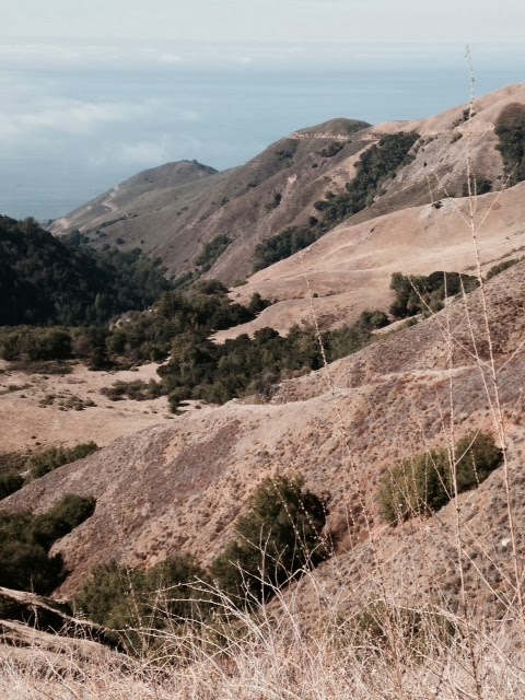
View from Santa Lucia coastal mountains, looking down from just east of Kirk Creek Campground.  This road will take you over the mountains to Mission San Antonio; very scenic but not for faint of heart!

McWay Cove and McWay Falls to upper left; part of Julia Pfeiffer Burns State Park

Bur Sur Coast, looking south towards San Simeon, taken from Hwy 1 overlook


Rugged Santa Lucia coastal mountains, taken on drive from Big Sur, headed east to Mission San Antonio, about 25 miles inland, due east of Big Sur coast

Lying just south of Monterey and Carmel, the Spanish called it “El Sur Grande”, the Big South, for the huge swath of rugged, unexplored and treacherous California coastline. Today, the 90 miles of Big Sur reaches from Monterey almost to San Simeon, home to Hearst Castle.

Though Mexico awarded several land grants in the early 1800s, none were settled and it would not be until about 100 years ago that permanent settlers arrived in the area. Soon, a lively logging economy began to thrive, with timber shipped up the coast to San Francisco.

Highway One was not completed until 1937, after 18 arduous years building this rugged and stunningly scenic highway. The completion of the road has led to a thriving tourist economy with marvelous resorts and restaurants and some of the state’s grandest state parks. If you are a camper, this is your place (and, on the coast, you can camp year-round)! We are fans of state and federal campgrounds, and these are gems, running from north to south along the highway.

Andrew Molera State Park, just 20 miles south of Carmel offers 24 walk-in sites (first come, first-served), where you park and hike about 1/3 mile to camp sites that will hold up to four folks. With 4,800 acres, the park offers a huge variety of exploring options, from beaches to the Big Sur River to the rugged coastal mountains. This is relatively undeveloped acreage; if you are seeking a wilderness experience, this is pretty close!

Pfeiffer Big Sur State Park, 26 miles south of Carmel, offers 169 sites, picnic options and plenty of hiking and swimming opportunities. The park covers over 1000 acres of redwoods, oaks, cottonwoods and conifers and offers glimpses of wildlife including deer, skunks, raccoons and a variety of sea birds. Hiking offers lots of options along both the Pacific Coast and the Big Sur River. The Big Sur Lodge also offers lodging, if you don’t desire to camp. Reservations: www.ReserveAmerica.com.

Julia Pfeiffer Burns State Park, 37 miles south of Carmel offers two hike-in campsites, which can be reserved through www.ReserveAmerica.com. Hiking options are abundant, with options from the Big Sur Coastline up into the rugged coastal peaks. The Overlook Trail takes one on a stunning hike along the coastline, leading to the McWay waterfall, which drops almost 100 feet into the McWay Bay. It’s worth the hike for one of the more spectacular spots on the entire coast!

Limekiln State Park, 56 miles south of Carmel, is one of our favorites. Carved into the Big Sur coast, if offers 716 acres and 33 developed camp sites, many with stunning Pacific views. Mighty redwoods make their way down to the water and the park features historic remains of limekilns, which produced copious amounts of lime for construction some 100 years ago. Reserve through www.ReserveAmerica.com.

Kirk Creek Campground is a bit further south, a gem perched on a bluff overlooking the coastline. Great views, beach hiking, open year-round on a first come, first-served basis, run by the US Forest Service. For more info, call (805) 434-1996.

Restaurants and dining range from the subtle to the sublime, from inexpensive to $$$$-rated! Featuring California’s number one-rated restaurant (by Zagat) and many other fine dining choices, our recent favorite is Big Sur Roadhouse newly opened, getting rave reviews and a bit less expensive than some competitors. Lodging choices abound along the Big Sur coast, from the much-awarded Post Ranch Inn and the Ventana Inn, to Treebones Resort (recognized as a world leader for eco-friendly resorts). A fine resource for both restaurants and lodging is the Big Sur Chamber of Commerce, www.bigsurcalifornia.org; (831) 667.2100.

Highway One is part of the Big Sur story, designated California’s first scenic highway. Spectacular coastal views (with plenty of overlooks), soaring bridges and endless beaches offer a host of wildflowers almost always in bloom, California Sea Otters cavorting in secluded coves and legions of sea birds - if you are lucky, you may see a California Condor soaring overhead on their seven foot wingspans.

Nearby destinations: to the north are Carmel and Monterey, with San Simeon and Hearst Castle to the south along Highway One. Mission San Antonio (one of California’s 21 Spanish missions) and Pinnacles National Park are just east (though, circuitous and wild and scenic drives are required to reach them)! Take your binoculars and enjoy Big Sur; for additional California and western destinations, see http://LittlePlacesIKnow.blogspot.com.

Wednesday, November 27, 2013

Mission San Antonio/Jolon/Fort Hunter Liggett, CA

Should you be the visiting the incredibly scenic Pinnacles National Park (just south of Hollister, CA), and decide you want to get over to the rugged Big Sur California coastline, an interesting and wildly scenic 90 mile drive will get you there.


Pictured, from top down: remains of the old Dutton House on edge of Jolon; Jolon's old general store; St. Luke's Church, founded in 1863; Mission San Antonio main chapel; interior of Mission San Antonio; and, remains of the mission's water system, that supplied water to the grist mill (remains seen in distance).
This drive takes you past the historic remnants of Jolon on the old El Camino Real, through Fort Hunter Liggett and the nearby historic Mission San Antonio. From there, it’s 25 more miles up over the rugged coastal mountains, dropping you in the middle of Big Sur on the California coast.

It's not a drive for big motorhomes, though cars and trucks do fine. We journeyed from Pinnacle's east entrance, south on Highway 25, to the intersection of Bitterwater, followed G 13 to King City, then G 14, passing Jolon, then west on G 18, stopping at Mission San Antonio, one of the original 21 California missions established almost 250 years ago. Then, 24 scenic miles to the Big Sur coast, dropping us near John Little State Beach and just south of Julia Pfeiffer State Park.

Along the way, the remnants of the old town of Jolon can be found, established in the 1860s to meet the needs of miners traveling to the Los Burros Mining District.  Of particular interest are the remains of the old Dutton House, which thrived from 1849 through 1886 as a tavern and hotel for miners and travelers on the El Camino Real. Jolon would become the social and agribusiness center in South Monterrey County. When the railroad came to King City, that town prospered and Jolon slowly faded away.  Today, you can find the ruins of the Dutton House, Jolon's old general store, St. Luke's Church and faded dreams! 

Jolon was acquired by William Randolph Hearst in the 1920s, and sold to its current owner, the US Army, in 1940. Ft. Hunger Liggett (http://www.liggett.army.mil) would then become an active Army training base for World War II, and continues today as headquarters for the U.S. Army Combat Support Training Center, serving multi-service active and reserve components. The military outpost encompasses approximately 165,000 acres, home to deer, mountain lions, wild hogs and occasional bears!

Mission San Antonio (http://missionsanantonio.net) is the historic prize of this trip; founded by Padre Junipero Serra in 1771, when he hung a bell in an ancient oak tree. Due to need for a better water supply, the mission was later moved ¼ mile away to its current site. The Native Americans of the mission were the Salinan Tribe, part of the Hokan family.

Before the founding of the mission, the native population thrived on a diet of acorns, seeds, berries and wild game. They would move into the mission’s buildings and build a very productive mission town, home to hundreds of Salinan members who set to work to further expand the mission and its infrastructure. Today, remnants of the first mission buildings, its water-powered mill, ovens and more have been uncovered, the old water system remains evident, and the current mission sanctuary is home to a thriving Catholic flock.

West of the Mission and Ft. Hunter Liggett, its a scenic, switch-backed road up and over the Santa Lucia Mountains to Big Sur. Plan a weekend or longer and bring your binoculars to see this historic and stunningly scenic part of “wild California”! For additional inspiring California destinations, see http://LittlePlacesIKnow.blogspot.com.

Thursday, November 21, 2013

Travels with a teardrop, other tiny trailers

We have owned several tiny trailers over the last six years; our first was a cute little reproduction Kit Kamper, popular after World War II and one of the more frequent teardrop trailer styles seen today. The Kit was built on a platform of 4’X8’ plywood sheets; hence, 4’ wide, 4’ tall and 8’ long (we have since upgraded to a Scotty teardrop, as noted below).

Pictured, from top down: Our reproduction 1958 Serro Scotty Junior teardrop, Susan relaxing in camp with the Scotty and its open rear galley (beside a giant fifth-wheel), and our 1964 Serro Scotty Sportsman (a work in slow-progress, behind the Nissan 300ZX we towed it with before we got the Focus)


Ours was built from a kit in 2004; we purchased it from its second owner who towed it with a Mini Cooper! We toured mostly California with this trailer - the North Coast, the Sierra and a few trips to other destinations. In 2012, we decided to up-size, and bought a slightly larger 1964 Serro Scotty Sportsman trailer (still teardrop in style, but offering a dinette, an interior sink and two-burner stove) but needing a pretty complete rebuild.

Shortly after, I sold the Kit for what I had paid for it, to a new owner in S. California. With the larger Scotty trailer wedged in our garage (awaiting more extensive work than I originally realized), I found on-line (eBay) a beautiful reproduction 1958 Serro Scotty Sportsman Junior, built in West Virginia in 2011 by a true craftsman. Since we were headed back to Gettysburg anyway (for a week-long bicycle tour with my brother and four other pals), I bought this cute teardrop and picked it up in route to Gettysburg.

The 1958 Scotty was also built on the 4’X8’ plywood platform) making it similar in size to the Kit. We have toured extensively with it, including the trip all the way across the country, a three week trip up the CA/OR and WA coasts to Vancouver, BC, across BC to Spokane and back, and assorted other shorter CA trips to national parks like Sequoia, Kings Canyon, Pinnacles and more.

The arguments for a teardrop trailer include small and lightweight (about 700 to 800 pounds), so a small car or truck can tow it and still deliver good gas mileage (we tow ours with a 2013 Ford Focus 5-speed stick and get 26 MPG). I take special delight in pulling up beside giant diesel pickups, pulling 35' fifth-wheels (and getting about 10 MPG), realizing we are about as comfortable as they are! 

With their small size, teardrops fit in your garage, and their relatively small interior space mean two bodies keep us quite warm, even when outside temps drop into the 30s!  Our interior sleepting space is 4'X6'5", so plenty of length and space for two.  Being a hard-sided trailer, my spouse Susan no longer worries about bear attacks, as she did when we tent-camped! 

The teardrops also have a rear galley that often have built-in stove tops and/or sinks; ours offers reasonable storage space for Coleman stove and other camp gear. We also equipped both our teardrops with a rear bike carrier receiver, so we can load 2-3 bikes on back.  With your bedding already made up, camp gear loaded, it's a simple matter to pack a cooler and your clothes, and away we go!  The cons include being small (not a lot of fun on a rainy weekend, though we have been known to hibernate and watch movies on a laptop for hours on end)!

Teardrops are not the only choice in small camping rigs, which also include both soft-sided and hard-sided “tent trailers”, and smaller, fuel-efficient vans decked out as creative campers. The marketplace for any of these is both Craig’s List and eBay (search for both tear drop, and teardrop campers); I frequently see nice teardrop trailers advertised from anywhere from $2,500 to $7,500, depending on how nicely equipped.

You can also find, on the web, varied companies that rent teardrops for a few days or a week. Try one out, you may become hooked on the comfort afforded and hard-sided security, vs. tent-camping!

Thursday, November 7, 2013

Pinnacles National Park, CA, a story of faults, volcanoes and eons of erosion!

Jutting up from the Gabilan Mountains south of Hollister, CA, are the spectacular remains of an ancient volcano – a volcano located 150 miles south, near Los Angeles! Pinnacles National Park lies on the San Andreas Fault, and is moving a few inches north each year, distancing itself from its mother volcano!


From top down, our campsite at Pinnacles Campground among ancient Oak trees; rocky canyon wall off the moderate Rim Trail; Bear Gulch Reservoir just above cave of same name; my spouse Susan at entrance to small cave in route to Bear Gulch Cave; and the stunning Machete Ridge, deeper into the High Peaks area.

It’s a landscape that features the effects of heat, water and wind constantly wearing away at an alien landscape, leaving rugged spines, deep canyons, eerie talus caves, verdant foliage, rushing streams and robust wildlife, from dear, wild turkeys and hogs, to the majestic California Condor with wingspans up to seven feet.

On a recent visit, we found light crowds and a very dry park scene (no campfires allowed in the one large campground, no smoking anywhere), but a lively and stunningly scenic place overall! We entered from CA Hwy 25, through the East Entrance, just 35 miles south of a very pleasant Hollister, CA (with a number of comfy motels, closest to the park). The park also has a West Entrance, from Hwy 146 out of Soledad, but no major visitor conveniences on this side (no road crosses this out-of-the-way national park).

We made our home for three days in the Pinnacles Campground, the parks only, but very nice, campground. Complete with store, visitor center, swimming pool (in season) and showers, if offers a wealth of trailer and tent sites, many with full electric hookups. And, a shuttle bus runs regularly, to take you to the two park main trailheads, about three miles away.

You cannot really get the flavor of Pinnacles without some hiking, so bring comfortable walking shoes and a water bottle. From the Bear Gulch Trailhead, a moderately strenuous one-mile hike takes you to the spooky Bear Gulch Cave (bring headlamps or flashlights) and Bear Gulch Reservoir; one can return on the Rim Trail for a change of scenery.  From this trailhead or from the Old Pinnacles Trailhead, one can venture further into the High Peaks area, for ventures to Balconies Cave and views of Machete Ridge and the Balconies Cliffs. This oddly sculpted landscape will leave you struggling for words to describe it!

This was our first trip; it made us hungry to return in the late spring and explore more of this stunning California wilderness. For more info on Pinnacles National Park, go to: www.nps.gov/pinn. And, plan a side trip to Mission San Antonio and to Big Sur (just south and west), while in this part of wild California! For other inspirational destinations in CA, see my blog http://LittlePlacesIKnow.blogspot.com!

Saturday, November 2, 2013

Kings Canyon National Park; deep canyons, majestic Sierra peaks!

Entering Sequoia National Park, you will see distant views of Kings Canyon and Sierra peaks nearing 14,000 feet (nearby Mt. Whitney, at 14,500 feet, is tallest in the lower 48 states, but a bit out of view).


Photos, from top, down: View at Road's End, with some of Sierra monoliths that are targets for technical climbers; quintet of Sequoias in the General Grant Grove stand guard near parking area; the General Grant Sequoia looms out of a forest of giants; rocky peaks of the Sierra rise from Kings Canyon; the Kings River, which (along with glaciers) scuplted the canyon; scenic view of the Canyon, cloaked in haze from nearby Sierra forest fires; our Scotty teardrop at a Kings Canyon overlook; the Roaring River Falls, just a few blocks hike off the main highway.


Kings Canyon National Park is a sister park to Sequoia; they share common borders and one entry fee gets you into both majestic parks. The entry into the park is through the western piece of the park, and soon you experience the General Grant Grove of Sequoias, amazing in the number of huge trees in a confined, walkable setting. Nearby Kings Canyon Visitor Center and Grant Grove Village offers sequoia and historic perspective; lodging and several campgrounds are available here.

Continuing towards the canyon, stunning Sierra views are offered at every turn. You traverse through Sequoia National Forest, past the scenic Hume Lake turnoff, privately owned Kings Canyon Lodge, a rustic hotel and Boyden Cave as one tours along the frothing South Fork Kings River.

Reentering Kings Canyon Park, stop at the Cedar Grove Visitor Center and Village for unique canyon insights. Take a break at Roaring River Falls viewpoint (short video of the Falls is above), where a short hike takes you to a picturesque waterfall in a granite canyon.

Continue on to Zumwalt Meadow and Roads End, where you will see a number of trailheads and climbers preparing to scale the walls of varied monoliths. Campers will find a host of scenic campgrounds in the Kings Canyon itself, and lodges offer plenty of indoor respites for the weary traveler. Neighbor Sequoia Park also offers additional campgrounds and lodging options; go to www.nps.gov/seki.

While driving, keep your eyes open for deer, skunks, coyotes and, occasionally, black bears! While visiting Kings Canyon, plan a day-trip or longer to Sequoia National Park, it’s neighbor to the southeast. The General Sherman Grove, the Tunnel Tree and other points of interest are not to be missed. For a great lunch or dining stop, try the Wuksachi Hotel, central to Sequoia, with a wonderful dining room and quaint bar.

Plan a weekend trip or longer to Kings Canyon and Sequoia National Parks; you will forever want to return! For more unique California destinations, see my blog, www.LittlePlacesIKnow.blogspot.com.