Thursday, January 15, 2015

Hetch Hetchy Valley and Reservoir; undiscovered but stunning part of Yosemite!

Hetch Hetchy Valley and Reservoir, looking east from trail on the north shore trail of the reservoir.

The trail along the north shore of Hetch Hetchy Reservoir, looking back towards the dam.

The Hetch Hetchy Dam, started in 1919, completed in 1923 and further heightened in 1938, it now floods the valley and creates a reservoir that is 8 miles long, and up to 300 feet deep.

Hetch Hetchy Watershed at top, the much-more visited Yosemite Valley (to the south) at bottom of map.

The Hetch Hetchy Valley and free-flowing Tuolumne River, in the early 1900s, before the dam was approved.

A portion of the ferocious Rim Fire of a year ago, that burned vast swathes of forest in and around Yosemite Park; this view looking to the northeast, into the Tuolumne River drainage, with Hetch Hetchy in distance.

The old post office in Chinese Camp, part of a three block Gold Rush ghost town, right on Hwy. 120, on the way to Hetch Hetchy and Yosemite Valleys.

Hetch Hetchy Reservoir and the Tuolumne Valley are close cousins to the mighty Yosemite Valley, virtually undiscovered and almost equally stunning.  Hetch Hetchy is just 115 miles and a scenic day-tour from Stockton!

The Hetch Hetchy Valley was the scene of one of the most epic environmental battles 100 years ago, as John Muir, the Sierra Club and other environmental groups fought to keep this valley pristine and free of development.

Muir's exploration of both Hetch Hetchy and Yosemite, and writings in the influential Century Magazine, helped to get Yosemite National Park established in 1890. However, the much less-visited Hetch Hetchy Valley portion of the park remained in peril.

San Francisco had eyed the valley for extending its water supply since the 1890s and applied several times to the federal government for water rights but was denied. The huge San Francisco earthquake in 1906, when much of the city burned, underlined the city's need for more water and turned the political winds in the city’s favor.

In 1908, US Secretary of interior Garfield granted the city the rights to development of the Tuolumne River, provoking a multi-year environmental battle led by the Sierra Club and John Muir. Muir observed, "Dam Hetch Hetchy! As well damn for water tanks the peoples’ cathedrals and churches for no holier temple has ever been consecrated by the heart of man".

In 1913, writing to Robert Johnson of Century Magazine, he pressed his argument, noting "The Hetch Hetchy Valley is a wonderfully exact counterpart of the great Yosemite, not only in its sublime cliffs and waterfalls and it's peaceful river, but in the gardens, groves, meadows and campgrounds on its flowery park-like floor". He would continue to fight the city of San Francisco to his death in 1914.

Muir's writings are archived at the University of Pacific and can be read online at go.pacific.edu/specialcollections.

In 1913, the US Congress passed and President Wilson signed the Raker Act, which permitted the flooding of the valley. Muir died the following year, bitter to have lost the fight. Construction on the O’Shaughnessy Dam would begin in 1919 and end in 1923; it was further heightened in 1938 and now supplies water to almost 2.5 million San Franciscans.

What remains is a still stunning valley and pristine 8-mile long reservoir, nearly the equal of Yosemite Valley, and visitors have this part of the park almost unto themselves and can still appreciate the treasure that so stoked John Muir’s soul.

One can drive to the parking lot right beside the O'Shaughnessy Dam. Views from the dam are memorable, but hike a half-mile or several miles along the north side of the reservoir for the most indelible views.  Hetch Hetchy’s relatively low elevation makes for one of the central Sierra’s longest hiking seasons, but, check weather forecasts for winter trips.

Looking up the valley, on the right one sees the massive Kolana Rock, on the left, the Hetch Hetchy Dome. The view extends east, up the reservoir and through the Tuolumne Valley; serious hikers can continue even further east into the Tuolumne Meadows area. Hikers will find varied views both remarkable, and reminiscent of nearby Yosemite Valley.

Crossing the dam, our trail took us past the base of Tueeulala Falls, dry for lack of snowmelt, and to the base of Wapama Falls, surging mightily with early snow melt. It's about a 2 mile hike from the dam to Wapama Falls on an easy, well-maintained trail (note to self: return in April or May to admire these falls when more water is flowing!).

The discussion over water supplied to San Francisco, and ongoing battle over restoration of the valley by removing the dam, continues – but entering our fourth year of California drought, probably won't gain traction in the near-term. Until then, pack your binoculars and camera and set forth on a serious day tour, or longer!  If you are planning a longer trip to Yosemite in general, include a day to tour Hetch Hetchy!

One of the side benefits of such a trip is you pass through a couple of historic towns worth a stop. Chinese Camp is a true Gold Rush ghost town, right on Highway 120. Take the walk down the three block stretch of Main Street, with an old abandoned hotel, post office, merchant’s buildings, rooming house and homes slowly moldering away. Just up the hill on Main is the St. Francis Xavier Mission Church/cemetery, established in 1854.  You will find family plots and pioneer tombstones dating to the 1860s.

Groveland is closer to Hetch Hetchy, also on Hwy. 120, a quaint Gold Rush town catering to tourists with the historic Groveland Hotel, jail dating to 1854 and Groveland Pizza, on north edge of town, a fine family food stop.

Camp Mather and Mather Family Camp, just nine miles from Hetch Hetchy, offers a store, restaurant and variety of accommodations, from cabins to lodge, in a bucolic wooded setting. Vast stands of scorched forest along Evergreen Road, both before and after Camp Mather, offer mute testimony to the ferocious Rim Fire of a year ago.

How to get there: From Stockton, 115 miles, 2.75 hours. Take Highway 4 east to Copperopolis, turn right on O'Byrnes Ferry Road, take a left on highway 120/108 and follow Highway 120 past Chinese camp and Groveland. Then, left on Evergreen Road to the reservoir.  Leave early, particularly if you want time to see Chinese Camp and Groveland; and this portion of Yosemite closes at 5 PM.

What to take: Pack cold weather gear, binoculars, camera and snacks for the trip. Fishing rods and your CA fishing license!
For more information: Yosemite National Park, go to www.nps.gov/yose; call 209/372-0200 (then dial 3, then 5) or by mail: Public Information Office, PO Box 577, Yosemite, CA 95389 (the park does charge a day-use fee).
For additional travel destination inspiration, see my blog: http://blogs.eSanJoaquin.com/Valley travel; to contact me, tviall@msn.com.
Happy travels in the West!

Sierra snows; skiing, boarding, XC, snowshoeing or sledding, just two hours from Stockton or Modesto!

View from Bear Valley's Day Lodge, looking northwest towards the Mokelumne River Valley.

A hungry lunch crowd enjoys the colorful Day Lodge at Bear Valley Resort.

Members of the 'Ski Bears' enjoy a lesson, with Bear Valley's Day Lodge in distance.

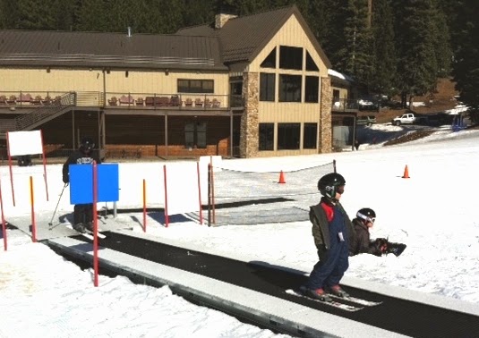
New skier takes the gentle carpet lift in front of the Dodge Ridge Family Lodge.

Members of the Dodge Ridge 'Kid's Club' enjoy a lesson on a sunny day.

A family of five enjoys both the snow and the scenery in the Boulder Creek Canyon area of Dodge Ridge Ski Area.
For Christmas, perhaps you received new skis or a snowboard, snowshoes or cross-country skis and want to try them out. Or, now that the holidays are past, you finally have time to get up to the Sierra snow country.

From Stockton, the two "closest snows to home" are Dodge Ridge Ski Resort 30 miles east of Sonora on Highway 108, and Bear Valley Ski Resort, 50 miles east of Angel’s Camp on Highway 4.

From my home in North Stockton, Dodge Ridge is 98 miles, Bear Valley, 106 miles – considerably closer than other options in the Sierra and Lake Tahoe areas Each resort is family-friendly, generally less expensive than resorts in the Tahoe area, offer good conditions at this point in early January – with each only about two hours from Stockton or Modesto.

Bear Valley Ski Resort is just off Hwy. 4, sports a top elevation of 8,495’, a mid-way day-lodge at 7,750’ and bottom elevation (the Grizzly Chair) of 6.595’.  Bear offers 1680 acres when fully open; with 8 chairlifts (one a high-speed quad) and two carpet lifts, with snow-making on some of its upper slopes.  Currently Bear has a 34+ inch base, is running six chairs and is about 47% open with packed powder conditions.
.
For scenic runs, try several off of Bear Top, where views can stretch south to Dodge Ridge and down into the Mokelumne River Valley.  Additionally, the Bear Valley Cross-country Center at Bear Valley Village (el. 7,100’) offers XC skiing and snowshoeing; they also rent platters, tubes for snow play.

Bear Valley spokesperson Rosie Sundell notes that “excitement is in the air, with recent new ownership by Skyline Investments.  Despite just acquiring the ski area, Skyline has invested in additional snow making equipment and has moved quickly to offer live music each weekend (Tracy native Megan Slankard plays on the Martin Luther King weekend; see Bear’s web site for a listing of coming events)”.

Bear Valley offers a variety of food and drink choices at its mid-way Day Lodge, including delicious outdoor BBQ when we visited last week.  Several dining options are offered nearby.  In Bear Valley Village, the Lodge offers light fare in the Grizzly Lounge and steaks and seafood in the classy Creekside Dining Room and has recently updated the Lodge’s Trattoria, with pizza, pasta and libations, for taking a large family with big appetites! 

A bit closer to the Valley, one can find numerous dining options in Arnold, and even more good eats in Murphy’s, including the highly rated Alchemy Restaurant and the historic Murphy’s Hotel.  Arnold and Murphys both offer a variety of hotels and motels for overnighting.

Dodge Ridge Ski Resort is just off Hwy 108 above Pinecrest Lake, with 8 chairlifts (one quad), one T-bar, two carpet lifts and a rope tow, a top elevation of 8,200’, base of 6,600’; 67 runs and 862 acres when fully open.  Earlier this week, the area reports sunshine, packed powder, plenty of groomed runs and 75% of their terrain open, including chairs 7 and 8.

Spokesperson Sean Waterman notes the area was “delighted to have opened on December 17, and experienced a fun and busy holiday season”.  He notes that the mountain is gearing up for several events, and the fast-approaching Martin Luther King’s birthday weekend. “Bring the family, we look forward to seeing you”, he adds!

Dodge Ridge prides itself on being a family-focused area, further enhanced when it opened its new Family Lodge a few years ago.  The area offers a variety of gentle slopes for beginning skiers and snowboarders and challenging “double black diamond runs” off Chair 8 in the Boulder Creek Canyon area. Check the stunning scenery serviced by Chair 8, with both easy and energizing runs and a view north into the Sierra that is spectacular.  Graceland is a favorite run, scenic, rated “blue” (more difficult) and a family favorite for both schussing and photos!

A number of cross-country ski trails emanate from the Dodge Ridge base area and access road. 
The resort is not permitted for sledding or tubing, but you can visit the Family Lodge, have lunch or hot chocolate and consider skiing, snow-boarding or a fun lesson.  The area around Pinecrest Lake (just below Dodge Ridge) offers several places where you can use those sleds or inner tubes, as does Leland Snow Play area, seven miles further east, just off Highway 108!

Dodge Ridge offers a number of dining options at the ski area, including the Creekside Lodge and Café, with a large variety of food and drink. On weekends and holidays, the North Fork Bistro in the Family Lodge is a great place for families to dine, and slopeside dining is also offered at Local’s Café, with tasty BBQ at the bottom of Chair 7.

Other reliable dining options are found nearby: The Pie Pizza in Sugar Pine, Mia’s Italian in Cold Springs or The Steam Donkey (steaks, seafood, pastas) in Pinecrest. Overnight lodging is found at Pinecrest Lake Lodge or Pinecrest Chalet in Pinecrest, the Christmas Tree Inn in Mi Wuk Village or the Long Barn Lodge in Long Barn, all along Hwy 108. 

If you are seeking snow play, with sleds, tubes or platters, you can find areas on the approach to both ski areas; however snow levels can vary by the day.

How to get there: The start of the route from Stockton is the same for both destinations; take Highway 4 east to Copperopolis.  There, to reach Dodge Ridge, go right/south on O Bryrne’s Ferry Road, then left/east on Highway 108 to the ski area. For Bear Valley, stay on Hwy. 4 all the way to the ski area.

What to take: Pack cold weather gear, binoculars, camera, snacks for the trip and chains are always advised for winter weather.

What’s nearby: Calaveras Big Trees State Park along Hwy. 4; Columbia State Historic Park just off Hwy. 49 (a Gold Rush town preserved) and Jamestown’s Railtown 1897 (the Sierra Railroad) just off Hwy. 108.

For more information: Bear Valley Ski Resort, www.bearvalley.com, 209.753.2301; Dodge Ridge Ski Resort, www.dodgeridge.com, 209.965.3474.

For additional travel destination inspiration, see my blog: http://blogs.eSanJoaquin.com/Valley travel; to contact me, tviall@msn.com.

Think snow, and happy winter travels in the West!

Thursday, January 1, 2015

California's epic destinations; update your "Bucket List" for 2015!


Point Arena Lighthouse on California's north coast, above the Russian River and Jenner.

The "ghost resort" of Bombay Beach, on east shore of the Salton Sea; a manmade ecological disaster.  The lake was formed in the early 1900s when the Colorado River flooded and roared down old irrigation canals, flooding the Salton Sink; a deep desert valley much like Death Valley.  In the 1970s, two El Nino winters further poured water into the lake, flooding and ruining five resorts around the land-locked lake.  These are the skeletons of former mobile homes on the lake shore.

The Bay Bridge connecting San Francisco and Oakland, as seen from a Hornblower Yacht cruise.  Photo courtesy of Les Fong.

Recreation of Sutter's Mill in Coloma, CA, site of the original California gold strike in 1848 and lead to the Gold Rush in 1849.

Machete Ridge, part of the newest of our 59 national parks, Pinnacles National Park, 30 miles south of Hollister, CA.

Lake Helen, still frozen in July, on road through Lassen National Park. That's Lassen's stark volcanic peak behind the lake.

We live in, arguably, the most spectacular state in America. With all the wonderful destinations at your beck and call and the start of a New Year approaching, I suggest you update your bucket list of California destinations for 2015.  To whet your appetite, here are some of our favorites – most of them in N. California.

Of California’s nine wonderful national parks, several stand out: Pinnacles, due to its close proximity to the valley and stunning topography.  When you journey to places like Pinnacles National Park, explore the surrounding countryside, which will yield other extraordinary places like Mission San Antonio just 30 miles south, and, across the scenic coastal range, the Big Sur coast. 

Have you made it to Lassen National Park, perhaps the most impressive park of volcanic and thermal features in the country? With mud pots, fumaroles and a volcano that exploded huge boulders for miles less than 100 years ago, it has to be on your list!  Further south, Death Valley is stunning for its austerity, particularly impressive in the spring when rains bring wildflowers in abundance. 

California's State Parks can't be overlooked, from Mt. Diablo State Park – you’ve seen it for how many years on our western horizon, but have  you been to the top, camped in it, and admired the 100 mile views?  How about Calaveras Big Trees and it's towering Redwood groves, or Big Basin State Park, northwest of Santa Cruz in the coastal mountains, oldest of the state’s parks and home to towering Coast Redwoods.  Spring is a fine time to visit these parks, with seasonal streams flowing full and wildflowers coming into bloom.

Have you fully explored San Francisco's unique waterfront? The City offers special places for walking, bicycling, public transit or auto.  Start at the Golden Gate Bridge and explore Fort Point, the only Civil War fort on the West Coast. Travel east past Crissy Field, through the Marina District and stop and explore the San Francisco Maritime Museum and the Hyde Street Pier where a dozen historic ships await your arrival, with Fisherman’s Wharf right next door. 

Skip SF’s tourist-stop Pier 39, continue on the Embarcadero to reach the renovated historic Ferry Building and explore a wealth of cute shops and eateries. Here you can take the ferry to Oakland and return, or take a Hornblower scenic cruise on the bay. Continue south, past AT&T ballpark, across the Lefty O’Doul Bridge into Mission Bay; soon you're in the heart of several commercial shipyards where you can see big ships lying in drydock for repairs. Unique ocean and bay vistas present themselves at every mile of such a trip!

Don't ignore the treasures of our San Joaquin/Sacramento Delta.  From backwater river towns such as Rio Vista, Walnut Grove and Locke, fishing for striped bass, salmon and crayfish, to scores of bucolic orchards and vineyards – you’ll find surprises around every turn.

California's Gold Rush history brings tourists from around the world. The site of California's Gold discovery in 1848 is in nearby Coloma; Mother Lode Gold Rush sites march south down the Sierra. Here you'll find wonderful, historic towns just waiting to be explored. Start at Coloma, include Placerville, Fiddletown, Sutter Creek, Columbia, Sonora, and finish your day tour in Jamestown’s Railtown 1897 (the “movie railroad, with locomotives appearing in scores of movies and TV shows).

Dig into your hometown's history, such as Stockton's. Line up a downtown historic walking tour (call the Downtown Stockton Alliance, 464-5246) and explore the Haggin Museum and San Joaquin Historical Society and Museum.  Discover historic nuggets such as Mokelumne City, which rivaled Stockton for both population and shipping supremacy before a huge flood wiped it off the map in 1861. You will find our city and county’s roots are deeply intertwined in the storied history of our state and region.

The magical Sierra offers so much to see and do. From Lake Tahoe, Yosemite, Sequoia and Kings Canyon national parks to big-time ski areas, with fishing, hiking, biking and camping opportunities close at hand.  Camp or hike at such meccas as Pinecrest Lake, Lake Alpine and the Arnold Rim Trail, all within 1.5 hours of town.

When traveling, watch for unique “by accident finds” like the Salton Sea, just south of Death Valley and Joshua Tree National Parks. A former barren valley well below sea level similar to Death Valley, it became an environmental disaster in the early 1900s when the flood-stricken Colorado River overflowed its banks and flooded the dry Salton Sink, forming a landlocked sea now 35 miles long and 25 miles wide.  The Salton Sea is surrounded by five ghost resorts, created in the 1970s after two very wet El Nino winters raised the lake level by 10+ Feet, flooding homes and ruining casinos.

Pick a favorite movie shot in California, even in Stockton, and explore the film locations. Sideways, which won an Academy Award in 2004, affords a fine day tour of the Santa Barbara County area, yielding film locations including the Hitching Post Restaurant, Los Olivos restaurant and a motel in Buellton, where much of the film was shot.  In Stockton, one can claim film locations such as the Lido Hotel, the old downtown bus station, the Hotel Stockton, University of Pacific and more, sites used in movies like Fat City, All the Kings Men and Raiders of the Lost Ark.

Visit California's north coast in the winter or early spring when you can have stunning ocean vistas all to yourself. The coast north of Bodega Bay is amazing, from quaint towns like Jenner and Mendocino, to beautiful oceanfront campgrounds to old Fort Ross dating back to Russian explorers.  Further north, you find Redwoods National Park and continuing California majesty.

So, take the New Year's start to update your own California bucket list – and, get exploring! No list can ever be complete, so polish up your own and share notable destinations that I have missed.  I’ll publish other reader favorites in my upcoming Record Valley Travel blogs!

For additional travel destination inspiration, see my blog: http://blogs.eSanJoaquin.com/Valley travel; to contact me, tviall@msn.com
Happy travels in the West!

Tuesday, December 30, 2014

Spectacular western US destinations; update your "Bucket List" for 2015


Wildflowers frame a receding glacier near top of Logan Pass in Glacier National Park!

The "Phantom Ship" rises out of Crater Lake, one of two islands on the azure blue lake.

The Grand Canyon offers many hues in late afternoon, taken from Mather Point.

A herd of bison graze peacefully in front of the Grand Teton Range in late morning.

Susan and author Tim Viall await eruption of Old Faithful Geyser in Yellowstone National Park.

Cleveland Indians warm-up before a game with the San Francisco Giants; Cactus League in Glendale, AZ.
We central Californians are blessed by close proximity to the American West’s incredible spaces, all within a several day drive or closer. With so many spectacular destinations at your back door and a New Year, take the time to update your bucket list of western destinations.  Two weeks ago, we offered insights into California’s incredible places (http://blogs.esanjoaquin.com/valleytravel); here are some of our favorites in the west.

Of the USA’s 59 national parks, several in nearby states stand out: California leads the nation with nine parks, Alaska has eight, Utah, five, Colorado, four, Arizona and Washington, three each and Wyoming two parks.  With the exception of Alaska, all are within a two-day drive of central California.  Our short list of favorites in the west are the Grand Canyon, Crater Lake,  Yellowstone and Grand Teton and Glacier Park. 

I first visited the Grand Canyon with my family as a 15 year-old, and several times as an adult.  Each visit comes with the jaw-dropping, catch-your-breath amazement that accompanies the first look into that huge, colorful abyss, some 5,000 feet deep in the Arizona high desert. 

A year ago, my wife and I recently approached the park’s south rim at 5 PM to find the canyon bathed in stunning hues from the setting sun - incredible!  This is a landscape to inspire the multitudes; the Colorado River runs 277 miles through the park, up to 18 miles wide and over a mile deep.

The majority of visitors enter the Grand Canyon at the south entrance. Tour the south rim, running for miles with unique vistas and history, including the Tusayan Ruins and Museum; noting the history of the native people that once made their life on the rim. Take a hike down the Bright Angel Trail used by mules to take people all the way to the canyon bottom – we hiked about a mile down the trail, then had approximately 700 vertical feet to climb out – definitely tougher than the trek down!

Near the top of our list is Crater Lake National Park, Oregon, just north of the California border and offering wonderous vistas. Start at the Crater Lake Lodge area on Rim Drive’s southside.  Walking to the crater’s nearby rim, that first view remains always inspirational.  Crater Lake, which filled a collapsed volcano’s caldera some 7,700 years ago, 5 miles across and 6 miles long, is the bluest blue you’ll ever see.

Yellowstone/Grand Teton National Parks are also must-dos.  Located in Montana and Wyoming, they offer a double shot of western beauty, sharing a common border.  Most visitors plan to spend several days in each park, to see Yellowstone’s scores of geysers and thermal basins and to share in the bison, elk, moose and stunning mountains that call both parks home.

A tour of Glacier National Park in north central Montana can be linked to a visit to Yellowstone, though the two parks are separated by almost 500 miles of monumental Montana scenery.  Glacier, home to most of the US’s surviving glaciers, is a gem of carved, rugged Rocky Mountains.  If you can add a few days, plan also to voyage north to Canada’s Lake Louise and Banff area, about 300 miles further north. 

For destinations “not quite a national park, but awe-inspiring none-the-less”, Mount St. Helens, WA, is a national monument and well worth the visit.  Just 50 miles northeast of Portland, a wonderful route shows the swath cut in 1980 when the mountain’s northside erupted with immense force.  Almost one cubic mile of the mountain’s northeast side exploded, reducing the once grand 9,677 foot peak to  8,365 feet, leaving a gaping, horseshoe crater. devastating an area about six miles wide and 20 miles in length and killing 57 people. Just 60 miles further north is Mt. Rainier National Park, so couple the two destinations into one. 

Mt. Rushmore National Monument, in South Dakota, though created by the hand of man, is also a destination for anyone’s bucket list and the surrounding Black Hills hold their own scenic rewards.

For cities with special urban delights, Seattle would rank at the top of our list.  With waterfront vistas almost everywhere, marvelous seafood dining, the old Pioneer Square area, the Space Needle and Pike Street Market, Seattle is an eminently walkable, bikeable and tour-worthy city.  Running a close second are Portland, OR, and Vancouver, British Columbia.  Each have similar attributes and their own special character to rank near Seattle.

Look for unique experiences that, coupled with great destinations in their own right, make for special memories.  Spring training baseball, late February to March, makes the Phoenix area an even more special place to visit.  Mix in a stop at the Grand Canyon, and you’ve added several noteworthy places to your expanding list. 

Fifteen major league teams make the Phoenix area their Cactus League headquarters.  Last March, we saw the Cleveland Indians beat the San Francisco Giants, and toured the parks of the Chicago Cubs, Oakland As and others. Or, couple a summer vacation with visits to football training camps for your favorite teams like the Seattle Seahawks and Denver Broncos!

When traveling, watch for unique “by accident finds” like the Imperial Dam on the Colorado River, just outside Yuma, AZ.  The dam and huge settling ponds allow sediment to settle before the irrigation water is pumped to the Imperial Valley, CA, one of the US’s largest agricultural regions.  Nearby is the eerie Salton Sea, a former barren valley well below sea level (similar to Death Valley).  It became an environmental disaster in the early 1900s when the flood-stricken Colorado River overflowed its banks, forming a landlocked sea now 35 miles long and 25 miles wide; floods in the 1970s created five ghost resorts surrounding the lake. 

Take the New Year's start to update your own Western USA bucket list – and, get exploring! No list can ever be complete, so polish up your own and share notable destinations that I have missed.  I’ll publish other reader favorites in my upcoming Record Valley Travel blogs!

What to take: fishing rods, good hiking shoes, binoculars and camera, maps and/or a GPS unit. 
Where to stay: The nice thing is that all these destinations have in-park lodges (many historic and memorable), fine campgrounds in beautiful settings and good-value motels nearby.  If you are a senior, get the America the Beautiful Pass, costing $10, getting you into most national parks free and saving you up to ½ off federal campgrounds! 
For more information on any of our National Parks, go to: http://www.nps.gov and pick your destination.  For insight into Seattle, go to www.visitseattle.org (or similar visitor sites for the other cities). For Phoenix and Cactus League baseball games, www.cactusleague.com.
For additional travel destination inspiration, see my blog: http://LittlePlacesIKnow.blogspot.com; to contact me, tviall@msn.com
Happy travels in the West!

On the trail of John Muir; the road runs through Stockton and UOP!


From top, down: John Burroughs on left, and John Muir, Yosemite, 1909; John Muir “Squirrelville letter” from the UOP archives, written in Sequoia ink, made from bark from the majestic trees (John Muir papers, Holt-Atherton Special Collections, University of the Pacifid Library, copyright 1984 Muir-Hanna Trust); Muir’s writing desk and cluttered study is left as the writer would have left it during a long writing stint; A small portion of the Muir peach orchards, with a period-correct horse-drawn sprayer; Drawing of Yosemite Valley in one of Muir’s field notebooks (John Muir papers, Holt-Atherton Special Collections, University of the Pacifid Library, copyright 1984 Muir-Hanna Trust); Muir home in Martinez, open to the public at no charge; and University of Pacific head of Special Collections Michael Wurtz with one of two Muir bookcases at UOP.
John Muir, the world's first conservationist, father of the National Park Service and cofounder of the Sierra Club, spent his adult years in nearby Martinez, California and more than occasionally traveled through Stockton. The largest collection of his papers, research and writings are archived in University of Pacific's climate controlled archive, open to Stocktonians.  His travels through  Stockton make him almost a native son!

Join us on the trail of John Muir – with nearby exciting opportunities to learn and explore!
Muir was born in 1838 in Scotland and immigrated in 1849 with his family to a farm in Wisconsin.

After reaching adulthood, starting university and then a factory job in a carriage works, an eye injury almost cost Muir use of his eye and led to his decision to begin a life of wanderlust.

In 1868, he traveled to California and quickly  visited the sights in Yosemite. He then spent three years living in Yosemite, much of it as a shepherd, built a small cabin and recorded his adventures in notebooks and journals. Muir always professed a difficulty in writing up his travels, but would become his era’s best known conservationist and champion of preserving our wild lands.

In Yosemite, he met and toured with Ralph Waldo Emerson; inspired by that author, Thoreau and others he began writing for Overland Monthly magazine in 1872, the same year Yellowstone National Park was established.

For The next 10 years, he traveled throughout the west, including many visits to Yosemite and the Sierra and several trips to Alaska before settling in Martinez.  There he would tend the fruit ranch owned by his father-in-law. His ongoing work to preserve and expand Yosemite, incorporate Sequoia as a park and interaction with President Theodore Roosevelt would lead to the establishment of the National Park Service.

During the late 1880s/early 1890s, he would campaign for Yosemite National Park, explore Muir Glacier in Alaska, and help found the Sierra Club and was elected its first president.

From 1882 to 1890, he lived in a nice home in Martinez; upon the death of his father in law, he and his spouse moved into their grand Italianate Victorian home on 2600 acres on the edge of Martinez.
In 1893, his first book was published, The Mountains of California.  In his lifetime, he would publish six volumes; four additional books were published after his death in 1914.

Muir also apparently traveled frequently through Stockton, one of the main jumping-off points to the middle and southern Sierra. He befriended at least one Stockton family, that of Edward Hughes, a Stockton teacher.

Hughes and Muir camped in similar Yosemite campsites, and Hughes worked to befriend Muir by taking the train to Muir's Martinez home.  Muir, in turn, would visit Hughes home in Stockton (since demolished) and letters between the two attest to their friendship and his visits to Stockton.

Muir's grand home is open year-round in Martinez, only an hour from Stockton, and is a wonder of his life and work. His study is preserved just as he left it, with this writing desk and many of his papers, and 300 of the estate's acres (once with over 50 varieties of peach trees) remain surrounding the home.

The home is testimony to his writings and life work; his writing study literally resonates with his indomitable outlook on wild America: “God never made an ugly landscape.  All that the sun shines on is beautiful, so long as it is wild…”, he wrote in the Atlantic Monthly, January, 1869. 

Later he would continue his strong advocacy for protecting America’s great places, noting in 1895: “Government protection should be thrown around every wild grove and forest on the mountains, as it is around every private orchard and the tress in public parks. To say nothing of their value as fountains of timber, they are worth infinitely more than all the gardens and parks of town”.

It's in the University of Pacific's archives – open to the public – where Muir's work really comes alive. I arranged a tour with UOP head of Special Collections Michael Wurtz, who arranged to show me many of his original writings and sketches.

I delighted in seeing several of his letters, written in Sequoia-ink, and his research books showing his sketches of Yosemite Valley, just as it looks today in photographs. The University contains the vast majority of Muir's writing and research notes, his original writing desk, and two bookcases full of his books.

Read several of Muir's works; a favorite, available in paperback or at the library, is ‘The Wild Muir’, which profiles many of his hair-raising adventures.  Typical of his matter-of-fact writing is this example; in 1875 he and a climbing partner were caught near the top of Mt. Shasta at 14,000 feet, he scribed:

“…down the ridge and past the hissing fumaroles, the storm became inconceivably violent.  The thermometer fell 22 degrees in a few minutes and soon dropped below zero.  The hail gave place to snow, and darkness came on like night.  The wind, rising to the the highest ;pitch of violence, boomed and surged amid the desolate crags,,,”. 

Muir and partner hunkered down amidst the fumaroles, alternately freezing and getting scorched, but survived the ordeal with only moderate frostbite!

Take the 60 mile journey to the beautiful Muir home in Martinez, and spend several hours touring his home and wandering through some of the peach orchards that remain. Just a mile away is historic downtown Martinez, itself a worthy side trip with stately Victorian homes and classic downtown.

Then arrange a tour of UOP's archives – or go online, - where you can see most of his recorded works so arduously scribed by the old conservationist more than 100 years ago and deposited with the university by his descendants, some of them UOP alumni.

The collection includes over 7,000 items of correspondence from 1858 to 1914, including from such luminaries as Emerson, Presidents Theodore Roosevelt and William Howard Taft and others.  Also included are 300 sketches by Muir and about 3,000 photos taken of landscapes or portraits of the author.

For more info: For U0P's archives, contact Michael Wurtz, 209-945-3105, mwurtz@Pacific.edu.  Many of Muir's writings and sketches are also available, online: go.Pacific.edu/special collections – and the University is seeking volunteers to help transcribe many writings not yet transcribed. For more info on the John Muir National Historic Site, 4202 Alhambra Ave., Martinez, CA 94553 go to www.nps.gov/jomu; or call 925–228–8860.  Muir's home is open daily, no charge, except for Thanksgiving, Christmas and New Year's holidays.

For additional travel destination inspiration, see my blog: http://LittlePlacesIKnow.blogspot.com; to contact me, tviall@msn.com

Happy travels in the West!

Sunday, December 21, 2014

Yellowstone and Glacier National Parks, Montana in winter; scenic, cold and uncrowded!


From top down: Buffalo gather at Yellowstone's Midway Geyser Basin; -38 degrees in West Yellowstone on car's dashboard thermometer makes for challenges getting car started (yes, we do listen to Bob Dylan on a long drive!); huge stuffed Grizzly in the Stagecoach Inn's lobby in West Yellowstone; a snowcoach warms up in West Yellowstone, awaiting the temps to rise to -25 degrees before park service will allow access into Yellowstone; Izaac Walton Inn on south edge of Glacier National Park is an old Great Northern Railway hotel, open to guests; Lake McDonald Lodge in Glacier National Park is the "end of the road" for vehicles in the winter; Lake McDonald shines in winter splendor at -13 degrees; stately mountains provide majestic backdrop behind barn in west central Montana.
Last January,  we headed to Whitefish, Montana, to join a group of ski patrol friends to ski at Whitefish Mountain (formerly, Big Mountain), tour into Glacier National Park and make our way south to Yellowstone National Parks.  I suggest such a winter trip should be on the bucket list for any outdoor enthusiast!

Weather the trip is to ski, to see our national parks or to take in the majesty of the west in winter, this trip does not disappoint.  We drove, from central California, through Nevada, north into Idaho and up through western Montana.  Most of the scenery is spectacular, roads are good and a host of inexpensive motels line the stunning route!

We made Whitefish on a sunny, clear but -5 degree, which got our attention (little did we know that would be the warmest day in the next five!).  Some of our group boarded the Monday morning shuttle to Whitefish Mountain, while my spouse and I slept in, then grabbed our cross-country skis and did a few laps on the cross country ski track, right outside our cozy lodge.  

The next day, five of us toured into Glacier National Park, just 28 miles to the northeast.  Temperatures had reached 13 below zero, and keeping warm was high on everyone’s list. During the winter, most of the roads in Glacier Park are not plowed, and closed to vehicular traffic. 

From the western park entrance we were able to drive 11 miles into the Park on Going to the Sun Highway, ending at the boarded-up Lake McDonald Lodge.  Here, hardy snowshoers or cross country skiers can continue east along the closed road. 

The tour along the southern shore of Lake McDonald offers simply stunning views.  We stood on the shore of the lake, with a wind-chill down to about -25, and listened to the slapping of white caps breaking on the shore, framed by the rugged snow-capped mountains across the lake. 

We then headed east along the park’s southern border.  In the town of Essex is the delightful Izaac Walton Inn, a unique year-round resort that caters to skiers and snowshoers in the winter.  The old inn is a Great Northern Railway hotel with inviting rooms, and it is surrounded by renovated cabooses and a Great Northern locomotive, all turned into cozy accommodations, with numerous cross-country ski trails leading to incredible scenery!

After our several frigid days in the Glacier Park area, it was time to head south to West Yellowstone and Yellowstone National Park.  Hwy 93 takes one south along the western shore of Flathead Lake, with snowy peaks framing the lake at every vantage point.  We turned east on I-90, past Missoula to Bozeman, as my spouse checked the Weather Channel app on her iPhone, noting that West Yellowstone was forecast to reach -25 degrees by the next morning.  Between Bozeman and West Yellowstone, we detoured off the highway to take a look at Big Sky Ski Resort, big-time skiing just outside Yellowstone Park.  But, by now, temps were dropping toward -25; Brrrrrr! 

We reached West Yellowstone just before dark, and spent the night at the Stagecoach Inn.  In January, but for snowmobilers, not a lot is going on (only a handful of restaurants and motels are open), so we had pizza across from the Stagecoach, turned in fairly early and waited for the coming cold morning.

The next morning, a motel attendant noted the temperature had reached -40 degrees overnight.  Sure…he must be exaggerating!   Shortly, I went out into the sunny morning to start my car – it would barely crank – the dashboard display registered -38 degrees!  After running down my battery, I called AAA.  Awaiting their arrival, I returned to the car 15 minutes later to get my hot cup of coffee, only to discover it frozen solid!

More than an hour later, AAA was able to start my car.  We learned that the Park Service was halting all entrants into the park (via snow coach or snowmobile) until the day warmed up to -25 degrees! 

Yellowstone Park can be entered in winter via three entrances, but only by snow coach or snowmobile.  Choices are from West Yellowstone (the west entrance), Mammoth Hot Springs (north) or from Jackson Hole/Flagg Ranch (south). 

On an earlier trip, we spent three days at the Old Faithful Snow Lodge, a quarter mile from Old Faithful Geyser.  It’s a four-star hotel, with 150 rooms and a cozy, full-service restaurant.  We chose the Frontier Cabin option, vintage cabins a block out back and less expensive than the nearby lodge.
We packed our cross-country skis, but used them only sparingly.  While several feet of snow was on the ground, plenty of walkers/snowshoers had packed the snow-covered miles of boardwalk so that we were able to hike the thermal basins and up to the Old Faithful overlook shod only in winter footgear.

During our stay we saw stunning Trumpeter Swans on the Firehole River and shaggy bison throughout the park, including a huge bull just 20 feet off the boardwalk on one of our walking tours (they come down to the geyser basins for warmth in winter). 

Old Faithful Geyser, only a short walk from our cabin, and the park’s many thermal features warmed our hearts during several brisk hikes – often, we would be the only observers when a geyser erupted!
We marveled at elk by the hundreds; in winter, they prefer to wander the park roads rather than wade through deep snow. 

The morning of our departure, a coyote followed us out the morning we left, seeking a handout; he’ll have to await our next visit! 

How to get there: From central CA, we headed east on Interstate 80, then north on Hwy 95 through western Idaho, then Hwy 12 over Lolo Pass, north on Hwy 93 through Missoula and past beautiful Flathead Lake to Whitefish.  Hwy 2 east from Whitefish will take you to Glacier National Park.
What to take: Binoculars and camera, of course, lots of winter clothing, and skis or showshoes if you are into that.  And, chains for your vehicle, even if you have a 4-wheel drive; jumper cables make sense if predictions of temps down to -20 or lower! 

Where to stay: In Whitefish, the Grouse Mountain Lodge (http://www.grousemountainlodge.com/) is a superior choice for cozy and classy accommodations in a lodge-like setting (Whitefish offers other good motel choices).  On the southern edge of Glacier Park, no more unique inns exist than the Izaac Walton Inn (http://www.izaakwaltoninn.com/).  In West Yellowstone, we have enjoyed the Stagecoach Inn (http://yellowstoneinn.com/; 406.646.7381) several times; in Yellowstone Park the Old Faithful Snow Lodge is the only winter choice (http://www.yellowstonenationalparklodges.com/). 

For more information on Glacier National Park, (406) 888-7800, http://www.nps.gov/glac/planyourvisit/winter.htm.  For snowcoach service into the park, the West Yellowstone Chamber of Commerce can offer choices of private snowcoach providers, (406) 646.7701.  For Yellowstone’s North park entrance (Mammoth Hot Springs) and south park entrance (Flagg Ranch/Teton Park) lodging and snow coach service, and Old Faithful Snow Lodge stays, contact Zanterra, the Yellowstone concessionaire, www.yellowstonenationalparklodges.com, (307) 344.7901.

For additional travel destination inspiration, see my blog: http://LittlePlacesIKnow.blogspot.com; to contact me, tviall@msn.com

Enjoy your travels in the West!

Friday, December 19, 2014

Favorite Western Streets: Stockton, CA's Miracle Mile is nostalgic shopping, dining mecca!

Stockton’s Miracle Mile, a stretch of Pacific Avenue running from Harding Way on the south to the University of Pacific on the north, was Stockton’s first suburban shopping center.  The Stockton Empire Theatre opened in 1945, and a host of shops and restaurants surrounded it.  Today, it remains a quaint, interesting, robust and nostalgic shopping district.

Many shops line the one mile stretch, from specialty shops, antique shops, florists, home improvement shops and many more.  The 10 block portion, from Harding Way north to Castle, is eminently walkable and full of surprises; just right for strolling and finding that special gift or treasure!

Some of the city’s best and locally-owned restaurants and night spots are located on “The Mile”.  Here’s an incomplete list, running generally from south to north, of our favorites: Manny’s, Taste of Korea, Saigon (Vietnamese), Whiskey Barrel Tavern, CoCoRo (Japanese), Centrale, The Ave, Whirlow's, the Abbey Trappist Pub, Mile Wine Company, Valley Brew, La Palma (Mexican), Sam's Café and Siamese Street (Thai). 

Take the time to tour this slice of Americana; for more information, go to the Miracle Mile Improvement District, www.stocktonmiraclemile.com, or call 209.948.6453.

For additional travel destination inspiration, see my blog: http://LittlePlacesIKnow.blogspot.com; to contact me, tviall@msn.com.
"The Stockton" was Stockton's first suburban theatre, opening in 1945 and anchoring the town's first shopping center beyond downtown.  It was remodeled into a four-screen multi-plex in the 70s, and renamed the Stockton Royal Theatre. 

Today's Stockton Empire Theatre is both a theatre and a performing arts center and anchors the shops and restaurants of the Miracle Mile District!

Happy travels in the West!